Grand Canyon Hotel Picture of the Week

Almost two centuries ago, a peculiar group of men earned a living by hunting and trapping wild game in the mountain west. That’s right; they were the Mountain Men. Although they were legendary, there were only about a thousand of them, and their heyday only lasted 20 years. They preferred pack mules to people, so they traveled alone. One of these men was exceptional and was admired even among his peers. They called him Ol’ Bill Williams.

The Arizona historian—Marshall Tremble—describes Bill as a 6 foot, skinny redhead with a high-pitched voice and a peculiar walk—more of a stagger. His Osage wife must have had olfactory problems because even his cronies complained that he should take a bath once in a while. I didn’t find any references about Bill’s Arizona travels, but he must have impressed many Arizonans because our state has a trail, an annual gathering, a river, a mountain, and a town named in his honor. That town is the anchor for our October project—Williams, Arizona.

Williams is another railroad town along Arizona’s northern east/west corridor. First Nation people, trappers, railroads, and dust bowl migrants stopped here because there’s water. It’s located on the Colorado Plateau about an hour west of the Flagstaff volcanoes. A few miles west of Williams, you quickly descend into the transition zone and the grasslands around Ash Fork.

Sultana Bar - Williams has a couple of proper dive-bars right out of a Micky Spillane novel.
Sultana Bar – Williams has a couple of proper dive bars right out of a Micky Spillane novel.

The current attraction of Williams today is Route 66 memorabilia. Shops line the historic downtown area selling posters, t-shirts, car signs, and other useless trinkets of that ilk. But that’s not what we’ll be concentrating on this month. I’ve already covered that in our Seligman series. Besides, I’ve already said that Route 66 may have already jumped the shark. Car stuff was important for my generation, and maybe the one following us. Millennials don’t seem interested in cars or property. Owning a car was our independence. To them, it’s a ball and chain.

Williams began as a railroad town on one of the busiest routes in the country. It also has a couple of exciting spurs. One that goes past my house into Phoenix and another that runs to the Grand Canyon. Santa Fe built that line to lure eastern tourists into seeing the park. That ride is still famous today, and passengers get dumped at the El Tovar Hotel. If you had deep pockets, you could hop a train at Grand Central Station and stay in two of Arizona’s historic hotels—the Railroad Hotel in Williams and El Tovar at the canyon.

Grand Canyon Hotel - The historic Grand Canyon Hotel's neon sign lights up a couple of blocks in downtown Williams.
Grand Canyon Hotel – The historic Grand Canyon Hotel’s neon sign lights up a couple of blocks in downtown Williams.

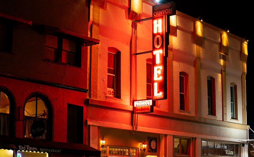
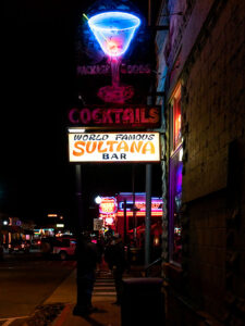
As I said already, I’m not going to focus (get it?) on the Route 66 stuff this month, but I couldn’t help myself when I saw the historic and bright neon lights—ooh, shiny. I love them, especially when they’re not working completely. So that explains this week’s featured image that I call Grand Canyon Hotel (or should it be H tel). I’m not sure that I’d stay there. It would be like staying at Miss Kitty’s Long Branch Saloon—dancing girls, cards, drunks, and gunfights all night long. The sign is the brightest on the street, and it casts its red glow for blocks.

Also, in the lower-left corner of the photo, you can see the Red Raven’s awning. Trip Advisor rates it the top restaurant in Williams. Queen Anne and I had a wonderful meal there. It’s a bit pricy but better than the rest of the burger-and-fries joints in town. I’ll write a complete review if you’re interested—that means begging me in the comments.

You can see a larger version of Grand Canyon Hotel on its Web Page by clicking here. Next week, we’ll start our tour of the Williams area, and you can see what we found. Come back then.

Until next time — jw

Five Cairns Picture of the Week

If you’ve ever hiked a backcountry trail, you know about cairns. They’re the road signs hikers use to stay on track. They’re simply piles of rocks high enough to be seen and reassure travelers that they’re following the right path. According to Wikipedia, cairns have been around throughout time all around the world.

I don’t know who has the time to build and maintain these stone piles, so I’ve concluded that it must be the Pixies. If you think about it, who else has the skills to precariously balance rocks on top of one another that magically survive wind and rainstorms? You never see humans stopping to build them. Yeah, it’s definitely the Pixies.

The markers confirm the obvious on some trails—like this month’s hike up the Little Granite Peak trail. The steep climb from the parking area to the first flat was like tromping through a rain gutter. Runoff and traffic have carved a trough that’s easy to follow. On the other hand, where trails traverse slick rock areas, cairns will reliably mark the easiest path. When I hiked to Coyote Gulch in Utah, there were long sections of trail where I had to stop at one of the cairns and look for the next one before I went any further. Later I found that the markers kept me from having to scramble down treacherous cliffs.

Another time that I remember cairns saving my butt was on the outing to Cedar Mesa. While Queen Anne waited in the truck, I hiked down into Cigarette Canyon to get this shot of Fallen Roof Ruin. She insisted that I leave the keys with her. After reaching the canyon bottom, I only had to trudge a mile before I spotted the ruin nesting high in the cliffs. Paying no attention to my route, I scrambled up the smooth sandstone wall with my camera and tripod.

Fallen Roof Ruin - Built high above a canyon floor, these ruins were a strenuous hike to get to, but a treacherous path down.
Fallen Roof Ruin – Built high above a canyon floor, these ruins were a strenuous hike to get to but a treacherous path down.

After getting my shot, I started my descent, but what I saw scared me. It was one of those steep hills where you could only see the first few feet before the ground plunged out of sight—like the first hill of a roller coaster. I had visions of rescuers finding my skeletal remains among the ruins because I became trapped there. Anne would surely get bored and drive off, leaving me to rot alone. But as I searched for a way down, I spotted a pile of rocks to one side, so I headed toward them. From there, I saw more cairns that made a zigzag pattern down to the bottom. Thank God I didn’t have to make Anne put down her book and get out of the truck to find me.

Five Cairns - This little cairn didn't like the way you looked at her, this little cairn didn't like the way you spoke to her, this little cairn hated the way you bumped into her, this little cairn thought you smelled, and this little cairn went "wee, wee, wee," all the way to the police station.
Five Cairns – This little cairn didn’t like the way you looked at her, this little cairn didn’t like the way you spoke to her, this little cairn hated the way you bumped into her, this little cairn thought you smelled, and this little cairn went “wee, wee, wee,” all the way to the police station.

So, imagine my smile when I reached the first intersection on the Little Granite Mountain trail and saw five miniature cairns lined up on top of a boulder the size of a small Toyota. This spot must be where the fairies had a picnic. It was off the path behind some bushes, so these weren’t actual trail markers. They were left by the little people having some mischievous fun.

You can see a larger version of Five Cairns on its Web Page by clicking here. Next week, we start a new project, so come back and see where the road leads us.

Until next time — jw

Sierra Prieta Afternoon Picture of the Week

I broke down and bought one of those dorky bicycle helmets. Not the pink and white one that Anne picked out. She only liked it because it came with a Hello Kitty backpack, ideal for carrying my Capri Sun juice boxes. Mine’s bright silver with a black visor, and when I wear it, I look like the cartoon character in Pearls Before Swine—Jeff the Cyclist. Women swoon when I ride by.

I didn’t buy a helmet as a riding accouterment; it was a practical choice. A couple of weeks ago, I fell off my bike and landed on my head in a neighbor’s front yard. Don’t worry, nary a scratch, so I got up and finished my ride, but I was all over Amazon the minute I got home.

The bike was an innocent bystander in the crash; the real culprit was my balance. I’ve had dizzy spells recently. They’re caused by the microscopic sand particles in my inner ear balance thingy—the vestibular system. Some of the particles in my ear have escaped, and when I tilt my head, they brush hairs and set off dizzy spells—vertigo.

As I was climbing the hill on my morning route, I looked down at the chain to see which gear I was in, and when I looked back up, my head started spinning. The spells usually only last a short time, so that I thought I could power through, but the bike kept drifting toward the left curb, and I couldn’t control the steering, so I stopped to get off. If I get dizzy at home, all I need is to touch a wall for balance. There was no wall in the street. I was on my way to the ground before I knew it. I landed on my back, and I pounded the gravel with the back of my head. I sat up and checked for anything broken or bleeding. Then, I glanced around to ensure that no one had seen me before continuing my ride when I found none.

I’ve already seen my doctor, and she gave me exercises to round up those little buggers, so I’m doing better. There are a few recalcitrant grains that still run loose in my ear, but we’ll get them back in their cage eventually.

The dizziness was a concern on this month’s hike, but I wasn’t affected on the trail. I guess that the strenuous exercise kept it at bay, but I touched every boulder and tree along the way to be safe. When I reached the top, I was rewarded with views like in this week’s image.

Sierra Prieta Afternoon - From the top of Little Granite Mountain Trail you can see south all of the way to the Weaver Mountains.
Sierra Prieta Afternoon – From the top of Little Granite Mountain Trail, you can see south all of the way to the Weaver Mountains.

I call this picture Sierra Prieta Afternoon, and in it, you’re looking south from the hilltop. Beyond the eroded granite boulders, there are three mountain ranges. The closest peaks—the ones with color—are the Sierra Prieta. The next range—the one that has the large rounded peak—is the mountains around Kirkland and Skull Valley. Finally, along the horizon on the left-center is a glimpse of the Weavers. Our home is down on the desert floor on their far side—four thousand feet below the point I was standing.

You can see a larger version of Sierra Prieta Afternoon on its Web Page by clicking here. Next week, I’ll finish with a whimsical thing I found on the Little Granite Mountain Trail, so be sure to come back.

Until next time — jw

Prescott Basin Picture of the Week

There’s a growing trend in the comedy routines that Queen Anne and I watch on YouTube’s Dry Bar channel. The bits poke fun at young people for not knowing about obsolete things my generation regularly used. I’m not sure if the joke is at the youth’s expense or if it’s simply us old farts complaining about change again.

To give you an example, one performer asked a teen in the audience to explain the relationship between a pencil and a cassette tape (the kid didn’t know what the tape was). Another was about the phone books we used to get each year. The fact that we had to look numbers up on our own was mind-boggling enough, but they couldn’t comprehend that the books were primarily used at grandma’s house as a booster seat. Finally, hold up a 10’ curly phone cord and ask a young person why it existed.

I uncovered another lost phone tradition this week after talking to a particularly annoying salesman. It’s known as the old 40mph-hangup. I learned it from my dad back in the age of unenlightenment. It has Zen-like qualities and resembles a marshal-arts move, but it more closely mimics the grace of a baseball pitch. I’ll try my best to describe it. After you’ve had your fill with the person at the other end of the line, you scream a final taunt—after all, you must have the last word—then as you lift your left leg, you begin to swing your right arm in a full roundhouse motion and slam the handset onto the cradle. It should bounce at least once. I saw my father shatter an old black Bakelite phone we were renting from Ma Bell. Although this hang-up never accomplished anything productive, it always put a satisfying exclamation point on your lunacy.

With remote handsets these days, they took away that small joy of life. No matter how hard you mash the End button, it’s silent. Your adversary doesn’t know if you hung up or the phone dropped the connection. I don’t own a smartphone, but vigorously swiping at the screen can’t be any better. Maybe someone could write an app that plays a recording of a loud car crash before disconnecting. That would come close. Kids don’t know what they’re missing.

Now we have to find another channel to drain all that excess adrenalin. I could have run up and down the Little Granite Mountain Trail a couple of times with that pent-up anger. I wouldn’t have even broken into a sweat by the time I reached upper flats. Instead, I had to stop constantly until the pounding in my ears subsided.

Prescott Basin - You can see miles in any direction from the flats on the Little Granite Mountain Trail, like this view of Prescott to the east.
Prescott Basin – You can see miles in any direction from the flats on the Little Granite Mountain Trail, like this view of Prescott to the east.

It was at one of those rest stops that I got this week’s featured image. Close to the trail’s top, it begins to flatten, and you can finally see above the trees. After I passed this Alligator Juniper, I stopped for a rest. Here, I could see Prescott in the distance below, so I couldn’t resist snapping a photo. The view was hazy from the humidity, so I’m sure it would be spectacular on a clear winter afternoon. I call this photo Prescott Basin. I hope you enjoy seeing it.

You can see a larger version of Prescott Basin on its Web Page by clicking here. Next week, we’ll walk around and take in more views from the top of the trail, so I hope to see you then.

Until next time — jw

Prickly Pear Fruit Picture of the Week

For September, I’m going to bring you something out of the ordinary. We’re going to put the clouds behind us, pull off the road, and get out of the truck. We’re going to go for a short walk down a path—well, it’s more like a hike up a steep trail. I survived, so you’ll be fine. I promise you’ll be fine.

The subject that I originally had in mind for this month was the Sierra Prieta Range. The name is Spanish and means Cold Mountains. They are an offshoot of the Bradshaws. If we went to the top of Prescott’s tallest building and faced west, you’d be looking at the Sierra Prieta. Then if we turned south, the mountains that we stared at would be the Bradshaws. The best-known icons of the Sierra Prieta are Granite Mountain, Little Granite Mountain, and Thumb Butte.

So, when the rains finally broke late this week, I hopped in Archie and drove up to the Little Granite Mountain trailhead. All I intended to do was get above the treetops and photograph some of the mountain peaks. However, the surrounding chaparral was so dense that I wound up where my trail intersects with the Clark Spring Trail—a mile and a half further and four hundred feet higher than I intended. The good news is that I frequently had to stop and rest, and when I did, I was able to shoot some pretty things around me. When I returned to my computer that evening, I changed my month-long project from an entire mountain range to a single trail—well, the first third of it.

Prickly Pear Fruit - A prickly pear growing in the shade of an alligator juniper in the Sierra Prieta Mountains.
Prickly Pear Fruit – A prickly pear growing in the shade of an alligator juniper in the Sierra Prieta Mountains.

The underbrush along the trail is a transitional zone. It’s where Sonoran Desert plants intermingle with those found in our mountains. This week’s contribution is an example. In the photo that I call Prickly Pear Fruit, a common cactus is growing in the shade of an Alligator Juniper. Y’all should know by now that I’m fond of subjects in dappled light, and that’s what drove me to my knees to get this shot.

I like the soft pastel colors of this plant and the complementary color of its ripening fruit against a background of deeper green ground ferns (or whatever they are). I guess the purple is the prickly pear’s way of saying, “Here, eat this part,” to javelina. They eat it like candy. But, the piggies disperse the seeds in their scat, so both parties benefit from the exchange.

As an aside, the fruit makes a great jam that is getting harder to find. It’s sweet and spicy, and I like that taste combination. Because it’s not widely sold, only local kitchens produce it. Our health inspectors have been shutting down the mom-and-pop shops because they don’t have extensive stainless steel production lines like big food producers. So—like moonshine these days—you have to know someone who knows someone—or roll your own.

You can see a larger version of Prickly Pear Fruit on its Web Page by clicking here. Next week, we’ll take a few more steps up the trail until I’m out of breath again, and you’ll see what I found while I rested.

Until next time — jw

North Weaver Shadows Picture of the Week

This is Augusts’ final post; the doves are skittery, there’s football on TV, and my astrological markers are lining up. Hmm—what do you think Mother Nature’s trying to say? For me, these are all precursors to summer’s end and the time when Arizonans will once again emerge from their dens. If we were smart, we’d form a committee to dress up a ground squirrel in a tux, call him Congress Cecil, and have him predict how many weeks of extreme heat warnings remain. The days will still be hot for another month, but soon the evening temperatures make being outdoors tolerable.

I should explain the skittery doves and astrological marker. September 1 is our state’s dove season, so doves begin to move to where the houses are because they have a better chance of not being shot. The day after hunting season closes, the doves return to the open desert and won’t be heard from until they get horny in the spring.

And yes, just like the ancient Anasazi, I have a special marker that precisely tells me when the spring and fall equinoxes happen. I didn’t carve a light-piercing spiral in sandstone as they did; instead, I use Bruce’s—my across-the-street neighbor—roof. Its ridgeline runs east-west, and on the mornings of the equinoxes, the sun comes up from its peak as I enjoy my coffee on my front porch. Y’all should come to join me on September 22. It would really freak out Bruce to see hundreds of people staring at his house at dawn.

North Weaver Shadows
North Weaver Shadows – With help from the setting sun, cumulus clouds cast shadows on the Weaver Mountains.

As I said, this is the last image in my August cloud project. The monsoon took a vacation this week, so the sun’s brought the heat back. It’s had a chance to dry out, and now the yard’s full of weeds. But, Arizona Highway 89 is lined with orange poppies, and I spotted a couple of Palo Verde trees with yellow blossoms. It’s like spring again, and I’m getting that familiar wanderlust feeling.

Our monsoon will be back with a vengeance in a couple of days. There’s a hurricane traveling up Mexico’s west coast, and there’s a good chance it will come up the Gulf of California. When storms do that, it brings more than isolated showers—instead, the whole state gets soaked.

This week’s cloud picture kind of shows the weather’s dry break. The sky is clearer with scattered cumulus clouds. It also shows that it’s not just the puffy white sky-meringue that is pretty, but their shadows make the mountains more interesting. In the photo that I call North Weaver Shadows, we see cumulus cloud shadows cast on the north edge of the Weaver Mountains with help from the setting sun. This is my favorite image in this series because my familiar mountain range is different—more interesting. For your viewing pleasure, I also hid a black cow grazing on the desert floor somewhere in the picture—if you can find it.

You can see a larger version of North Weaver Shadows on its Web Page by clicking here. Next week, I’ll start a new September project. With the coming weather change, I hope I can get some shots in by then. So, be sure to come back and see if Dudley Duwright rescues Lit’l Nell from the railroad tracks in time (if you think about it—if he’s not in time, it’s not much of a rescue—is it?).

Until next time — jw

Sun Rays Picture of the Week

My first photography class was a half-century ago. I had just come home from a year-long tour in Korea with a brand new Nikon F2, and I wanted to learn how to be a photographer. I was stationed in Pasadena at the time (I’d tell you what I did, but then I’d have to kill ya,) and Al Bowman—an old friend—convinced me to sign up for a Pasadena City College night class. As frequently happens with crafts-centered night classes, it was more of a club. Everyone got an A, and the same people always attended each semester.

I no longer remember the instructors’ name, but he had been published in a couple of journals, so his credentials were impeccable to us. Although I wanted to shoot black and white in Ansel Adams style, our classwork was shot using Kodachrome. Each week the teacher would show our work on a Kodak—antique, even then—slide projector that he liked because it was bright and had an exceptional lens. It was essentially a portable searchlight that showed even the most minor flaws when closely viewed. It also doubled to signal Bat Man.

Even in those days, Ansel Adams was the master of landscape photography, but cover shots on Life, Look, Saturday Evening Post, and others of that genre were color. They all followed the formula we read in Kodak’s How to Make Good Pictures—a bible for beginning photographers (I still have my thread worn copy).

The method of shooting landscapes in the book—and what the instructor taught—was that you find an interesting background and properly compose it within your frame, then get a model (wife, friend, stranger) to pose to one side as if they were taking in the beautiful vista. Your model should be wearing something red or bright yellow to capture the viewer’s eye. Finally, if there’s any possible way you could get a sun flare to shine on your model, that was the cherry on the sundae. That classic nature shot had been de rigueur since the thirties.

It was so pervasive, it was trite, and it wasn’t how Ansel shot, so it turned off photographers like me. We felt that there was beauty in nature even if no one was there to enjoy it, and sunrays … really? Although I’ve seasoned over time, I still avoid light beams glowing from clouds. It’s become ingrained. Maybe I’ve over-corrected because of those days.

Sun Rays - Light beams radiate from clouds near Hillside, Arizona.
Sun Rays – Light beams radiate from clouds near Hillside, Arizona.

Those conflicts came to a head with this month’s cloud project. I wanted to show the pretty side of our Monsoon Season, so I’ve been capturing clouds all month. On my last outing, I concentrated on the eastern sky as I drove north to Hillside. The clouds billowed in pure white as they built in the afternoon sun. However, there was a darker, more brooding cell on the left side of the road, but it had shafts of light beaming from it. For miles, I tried to ignore it because it looked too different from my other shots, and <shudder> there were sun rays. It followed me for miles like a puppy wanting attention, so I finally gave in and took this week’s photo that I call Sun Rays. I hope you’re happy since I broke one of my rules, but I will not put a model wearing a red coat in one of my photos—unless that’s all she has on.

To get a shot like this, you have to shoot towards the sun and make sure it’s hidden from the lens. Otherwise, its bright light will wash out the detail around it. Another consideration is how you treat the foreground. In this case, I over-exposed the shot to get some texture in the mountains and then brought back the sky in post-production; otherwise, the ground would have been a lifeless silhouette.

You can see a larger version of Sun Rays on its Web Page by clicking here. Be sure to come back next week to see what happens next.

Until next time — jw