Meadow Cottonwood Picture of the Week

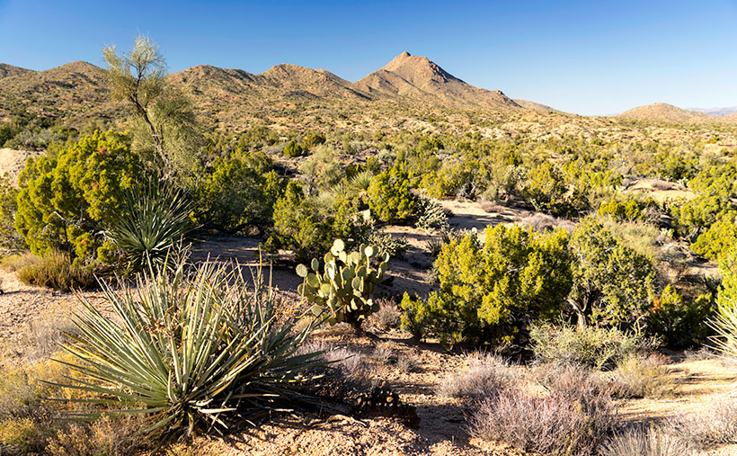
The part of Yavapai County where Queen Anne and I live is littered with the names of pioneers that came to Arizona looking for gold after the gold rush in California panned out. These places include the towns of Wickenburg, Yarnell, and Stanton—the Weaver Mountains—and Peeples Valley. I didn’t misspell the valley name. It’s not a great commune up there in the mountains, but a rather a lovely flat valley named after a prospector named A. H. Peeples.

I’ve mentioned him before in previous posts. With a set of initials like that, I was relieved (although disappointed) to find that his full name was Abraham Harlow Peeples. He was on an Army expedition lead by Captain Joseph Walker and guided by Pauline Weaver—who, despite the name, was a man. While camping along a creek, some horses (or mules, depending on which story you read) wandered off during the night. Walker sent a couple of wranglers to fetch the animals. When they returned to camp, they talked about gold on top of the hill and showed pockets full of nuggets. Peeples and the rest of the party went to see for themselves. Arizona Place Names said that Abraham picked up $7,000 in gold before breakfast—and that’s in 1863 money. Anyway, he used his new wealth to build a ranch in the valley that bears his name.

Before Anne and I settled in Congress, we looked at several homes up there. It has advantages. With a higher altitude, it has milder summers but doesn’t get snowed in during winter. The valley has beautiful mountain views with the Bradshaw’s to the east the Weaver Range on the south. The little town has a bar and convenience store. What more could you want? However, the closest grocery store is the Safeway in Wickenburg, and that’s where we buy groceries now—fifteen miles in the other direction.

The Maughan Ranch owns most of the land in the valley, and they keep adding to their property. Along Az. 89, there are painted white fences, with black cattle grazing behind them. Our real estate agent joked that the painters are full-time staff because they’ll never finish.

Meadow Cottonwood - a single tree grows in a meadow ravine ensuring a good water supply.
Meadow Cottonwood – a single tree grows in a meadow ravine, ensuring a plentiful water supply.

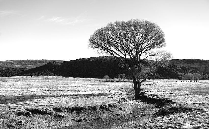
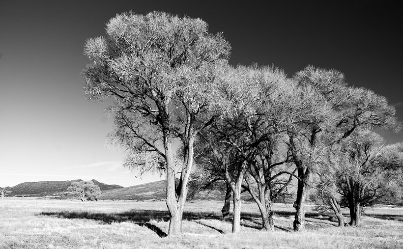
Lucky for me, the fences don’t block the view of the trees featured in this month’s set of photographs. For this week’s featured image—called Meadow Cottonwood—I leaned against the fence to brace myself when I snapped the photo. This dormant cottonwood is a middle-aged tree that found a meadow ravine to grow in. Backlit by the sun, I’m happy how the delicate branches contrast against the white sky.

You can see a larger version of Meadow Cottonwood on its Web Page by clicking here. I hope you like it. Be sure to come back next week for another cottonwood portrait from Peeples Valley.

Until next time — jw

Cottonwood Grove Picture of the Week

I want to begin this week’s post by thanking Deb Poteet for her advice about wearing fish-net stockings. If you missed what she said, it was a helpful comment to last week’s post. She said that she got her information straight from the Candy Store dancers—the gentlemen’s club on Cave Creek Road near Costco. It made both Queen Anne and me wonder what she was doing hanging around old strip clubs. Deb really does surprise us sometimes.

On another subject, Her Majesty is improving with each day. She goes to physical therapy three times a week and limps around the house without her walker or a cane. When I remind her that she doesn’t need to do that, she drops the Chester impersonation. It’s interesting to see how fast a woman can recover when you walk up to her death bed with a bottle of Dawn dish detergent and ask, “How much of this do I put in the dryer?”

Cottonwood Grove - A small grove of cottonwood grow along a dry brook in Peeples Valley, Arizona.
Cottonwood Grove – A small grove of cottonwood grows along a dry brook in Peeples Valley, Arizona.

Meanwhile, back up the mountain in Peeples Valley, and the second in my series of cottonwood tree images. This week’s featured image that I call Cottonwood Grove was another image taken on the Maughan Ranch north of town. Like other members of the Poplar family, these large fast-growing trees only grow where there’s a good water supply. In this image, there’s about a half dozen growing along the banks of a dry brook, which eventually feeds Kirkland Creek. Scenes like this one are familiar throughout the west.

In an Arizona Geography class that I took at Arizona State University, the professor told us how the trees filled the length of the Salt River bed. A family of beavers dammed the river under the Mill Avenue Bridge while the river still flowed. When the Corps of Engineers built the dams east of town, the Salt River stopped flowing, and the trees died, rotted, and eventually, a summer monsoon storm blew them over. That would have been a swell topic for a photo essay, but I wasn’t here then.

You can see a larger version of Cottonwood Grove on its Web Page by clicking here. I hope you like it. Be sure to come back next week for another cottonwood portrait from Peeples Valley.

Until next time — jw

Broken Cottonwood Picture of the Week

Well, I might as well tell you right off, because you’re going to find out anyway. I’m cheating on this month’s project. I didn’t search out a new back road for us to explore. Instead, I just drove up the highway to Peeples Valley and photographed old cottonwood trees that I’ve meant to shoot for the last couple of years. I guess you could consider Arizona 89 off the beaten path if you’re used to driving I-17 to Prescott, but it’s the way we go to Costco all of the time, and it’s the official route for every car and motorcycle club tour every weekend.

The reason I shirked my responsibility this month is that I had to put Queen Anne down—wait, that’s not right—oh yeah, she had knee replacement surgery, and I’ve been wearing two extra uniforms since. I’ve been her nurse and maid, and quite frankly, I prefer the white stockings because my toes keep getting caught in the fishnets.

When she first came home from the hospital, her knee looked like a sewed up bag of haggis—that’s the Scottish delicacy of oats and various animal parts boiled in a sheep’s stomach. It was black and blue with stitches that could make Frankenstein jealous. She was all doped up on pain medication and spent most of her time in bed. When she did get up, she’d hobble on her walker to the bathroom or eat a cup of food.

In less than two weeks, she’s moving much better and can make her way through the house without assistance. Now she’s going to rehab three times a week where they ask her, “How far can you bend your knee before it hurts?” After she demonstrates, they grab her leg and bend it further. The whole town of Wickenburg knows when that happens—sort of like the Pit of Despair in The Princess Bride. It seems to work though, because she has more movement each day, and she’ll soon be back to normal. I do think shes enjoying being waited on hand and foot because she milks it for all she can get. She even claims the doctor said that ice cream was medicinal.

Enough about her, let’s talk about photography. As I said, we frequently travel through Peeples Valley, where there is a large cattle ranch—Maughan Ranches—with white fences lining each side of the highway. In the green pastures, there are some very old cottonwood trees that I find appealing, so on a Saturday, when I was able to escape, I drove up and spent a moment behind the camera. After looking at images on my screen, I decided that since it’s winter and there’s no leaves or color, I would process them in black-and-white. In all, I think it shows the subjects off much stronger.

Broken Cottonwood - A pair of cottonwood trees, where one has fallen leaving the survivor leaning precariously in Peeples Valley, Arizona
Broken Cottonwood – A pair of cottonwood trees, where one has fallen leaving the survivor leaning precariously in Peeples Valley, Arizona

This week’s featured image is called Broken Cottonwood. It shows half a pair of old trees. One of them has fallen from decay or rot whose remains litters the ground. The second tree leans to the left to avoid crowding. Now that it stands alone, it leans precariously, like Grandpa McCoy on his cane. There’s a tension in this shot that the little windmill on the right seems to balance.

You can see a larger version of Broken Cottonwood on its Web Page by clicking here. I hope you like it. Be sure to come back next week for another cottonwood portrait from Peeples Valley.

Until next time — jw

Mount Tipton Wilderness Picture of the Week

Since our trip to Pearce Ferry, I’ve written about the Grand Wash Cliffs, and rightly so. Last week, I mentioned that they formed the western edge of the Colorado Plateau and that the great river bisects the cliffs. But the Hualapai Valley has another mountain range on its west flank, and they’re the Cerbat Mountains. They fill the 23 miles between Kingman and Dolan Springs. On the drive to Las Vegas on US 93, they’re to the east side of the highway as you travel north through the Detrital Valley.

There are some old mines located in the Cerbats; Cerbat, Mineral Park, and Chloride. Traveling north from Kingman, you first pass the ghost town of Cerbat, which is hidden at the end of a challenging (4wd) road. The next is Mineral Park, which is due east of Santa Clause (that’s another story unto itself). Finally, the biggest one is Chloride—whose tailings are visible from Highway 93. I think Chloride is still active, but I don’t know for what they’re digging.

Mt. Tipton Wilderness Area - The jagged peaks in the Mt. Tipton Wilderness Area are at the north end of the Cerbat Mountain Range.
Mt. Tipton Wilderness Area – The jagged peaks in the Mt. Tipton Wilderness Area is at the north end of the Cerbat Mountain Range.

More interesting to me is the Mount Tipton Wilderness Area, which is almost at the northern end of the Cerbat Range. At 7148 Mt. Tipton is the tallest peak, but the wilderness area also has some jagged peaks that made me stop to take this week’s featured image—even though the sun had gone behind the looming storm clouds. I named the photo Mt. Tipton Wilderness, and it shows dried grasses and creosote bush against the barren granite mountains.

On the whole, I enjoyed our drive to Pearce Ferry. There were a lot of beautiful sights found there, and I can see returning in the future to do more serious photography. That’s the downside of these trips. They’re to photography what Cliff Notes are to books. To get the best results, you need to study and understand the subject.

On the other hand, we’ve only begun to explore Arizona’s back roads, and there’s so much more to see. I feel like I wasted the first two-thirds of my adulthood working for a paycheck. However, I understand that I wouldn’t be here if I hadn’t. I hope I have enough time to finish it all.

You can see a larger version of Mt. Tipton Wilderness on its Web Page by clicking here. I hope you enjoy seeing it. Next week I have a surprise for you. Something completely different, so I hope we’ll see you then.

Until next time — jw

Poachie Yucca Bloom Picture of the Week

Sometimes it’s frustrating to talk to foreigners—that is, people that live outside of Arizona, especially someone that has never visited here. When they find out you’re a Zonie, they turn their noses up, and usually, something like this falls out of their mouth, “How can you tolerate that heat, sand, and barren desert?” To them, our state is one homogenous sandbox inside an oven. They never ask, “Where in Arizona do you live?” That’s because no one has educated them about how diverse the state is.

Arizona has every climate zone but two: the Tropic and the Arctic zones. If you want to freeze your butt off, you’re out of luck, but San Diego is a good enough substitute for the tropics—at least for us. If you need something more hot and sweaty, you can always rent Cannibal Women in the Avocado Jungle of Death from Amazon, but I digress. Seriously, we have snow-capped mountains, high plateaus, transition grasslands, and four kinds of deserts. What more do you need?

After making these back road junkets for over a year, I’m finding out that there are even pockets of places that are different than what I expected to find there. Locations with their micro-climate, because they get more or less sun, wind, or rain than their surroundings. That’s what I got from this month’s trip over the Poachie Mountains. We saw water in a dry river, and evergreens growing alongside tall saguaros.

Poachie Yucca Bloom - A yucca high in the Poachie Mountains that still has its flower stalk.
Poachie Yucca Bloom – A yucca high in the Poachie Mountains that still has its flower stalk.

That brings us to this week’s featured image. It’s a photo of the ubiquitous yucca, a plant found throughout the southwest. They’re most photogenic when in bloom, which is spring. The yucca sends out a shoot with white edible flowers (but not raw) that fall off after pollination, and the seeds disperse in the wind. After all of the sex part is done, the stalk dries and falls off. In this case, the stem is still there, long after I believed I could get a shot like this.

Another thing about photographing yucca, they are always too far of a hike, surrounded by other plants, or not as symmetrical as this specimen. Whoever planted this one put it in a spot specifically for lazy photographers. I tip my hat to you, Mister Gardener.

You can see a larger version of Poachie Yucca Bloom on its Web Page by clicking here. I hope you enjoy viewing it. Join us next week as we travel down another one of Arizona’s back roads.

Until next time — jw

Greenwood Peak Picture of the Week

I have two reasons for these monthly jaunts on Arizona roads I’ve never traveled. The first is to give me a reason to get out and shoot. The other purpose is to force me to explore places I haven’t seen, see what’s out there, and see what I haven’t seen.

What was new to me on this trip was seeing saguaro growing among the Juniper. Think about it. The mix of those two plants never happens. The saguaro stops growing at about 3000 feet because they don’t tolerate frost. To be in a field of Juniper, you’d have to travel to Sedona, Prescott, or Payson. I yammered on and on about this phenomenon, Anne, as 17 Mile Road twisted up into the Poachie Range. At one point, I was so confused that I stopped and pulled out my Garmin to check the elevation.

Greenwood Peak - One of the two prominent peaks in the Poachie Mountain Range. This one can be seen if you travel through Wikieup.
Greenwood Peak – One of the two prominent peaks in the Poachie Mountain Range. Greenwood Peak can be seen on the western horizon if you travel to Wikieup.

The Poachie Range is 30 miles long, and you see them west of U.S. 93 between Nothing and Wikieup. They’re not very tall, with its tallest peak being Arrastra Mountain at 4807 feet. So, I usually wouldn’t expect to see Juniper this low. When I checked my GPS, the elevation was 3600 Feet. All this leads me to believe that winters aren’t severe here, but more rain falls here than on the desert floors. Anyway, that’s my story, and I’m sticking to it.

The road we traveled crossed the Poachie Range south of its prominent northern peak—Greenwood Peak. It’s the subject of this week’s featured image. It only rises to an altitude of 4300 feet, but it still provides a handsome backdrop for the unusual mixture of cactus and evergreens.

You can see a larger version of Greenwood Peak on its Web Page by clicking here. I hope you enjoy viewing it. Join us next week as we finish our trip to the Harquahala Mountains.

Until next time — jw

Big Wet Sandy Picture of the Week

“I know a shortcut.”

How many of you have heard those words and broken into a cold sweat? The road that Queen Anne and I decided to explore this month didn’t start as a shortcut. It was supposed to be a much longer trip, but it got cut short.

I had intended to drive to the north shore of Alamo Lake. There are a couple of exciting mountains I’ve seen from across the water when I last visited. The best road to get there starts in Wikieup. On my maps (including Google), there are two ways to get there. One is twenty miles south of Wikieup, and the other is about five miles south. Both roads go to the little town of Signal. I’m sure you spotted the signs on a drive to Las Vegas.

We decide to take 17 Mile Drive road. It’s the first left after the Nothing Gas Station. It’s a wide well-graded dirt road that climbs over a pass in the Poachie Mountains, then down into a valley where Signal is. The scenery at the pass is amazing—something we’ll get to later—and you can drive the route with your family station wagon. There’s one hitch along the way, and that’s crossing the Big Sandy River at Greenwood. Usually, crossing the river here could be tricky because—well, it’s deep sand, and you might get stuck without four-wheel drive.

Big Wet Sandy - The normally dry Big Sandy River flowing with water from recent rain.
Big Wet Sandy – The normally dry Big Sandy River was flowing with water from recent rain.

That wasn’t the case today. The Big Sandy was a real river and not in an ugly flash flood kind of way. Its waters flowed like it was an old river; clear and quiet. If I didn’t know better, I might have been tempted to pull out my waders and fly rod and make a few casts. It wouldn’t have been my worst day fishing, being the great angler that I am. There was no way to tell how deep the water was. It could have been two feet or a dozen, but it was not tempting enough for the police to cite me under the Stupid Motorist Law.

So, we’ll begin this month’s journey at the end and go backward. As I said, there was enough material to shoot in the mountains to fill a month, so we’ll save Alamo for another month, and we’ll start at the water’s edge.

I took this week’s featured image standing on the river’s bank. If I didn’t know, I would venture a guess that it was a photo of the Colorado River south of Bullhead City, and the mountains were in Nevada. Nope, it’s all Arizona. We’re looking north-east, and the peaks are actually on our side of the Big Sandy. The high point is Burro Peak. Although everything appears calm on this warm winter afternoon, the banks on each side of the water show erosion from raging water at some time. There are more cliff-banks like this—some higher—along the riverside past Wikieup that you can see from Highway 93. I wonder if I’ll ever again see a sight like this.

You can see a larger version of Big Wet Sandy on its Web Page by clicking here. I hope you enjoy viewing it. Join us next week as we start our return over the Poachie Mountains.

Until next time — jw