Cholla Bay Picture of the Week

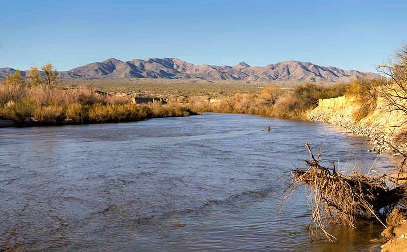
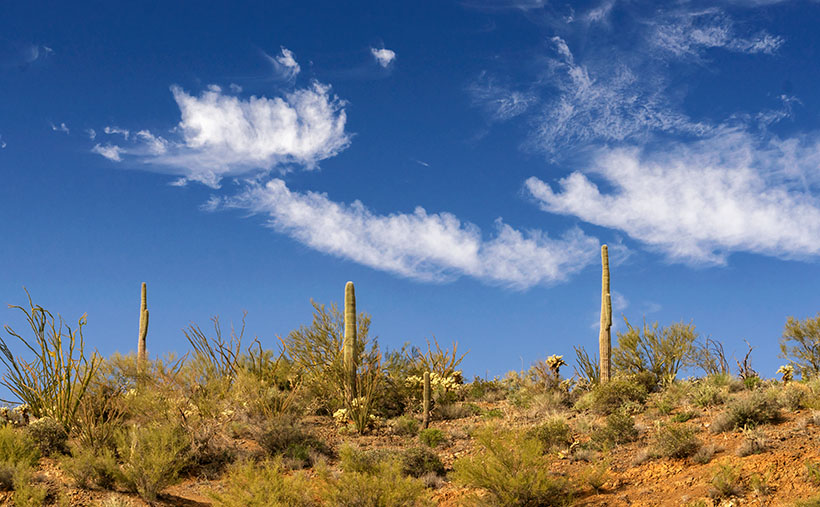
After being stopped by a river that rarely has flowing water, we spent some time along the bank of the Big Sandy, watching the calm, almost clear water flowing on its way to Alamo Lake. Queen Anne broke out a couple of water bottles, and we shared a trail bar while perusing the map to find our options.

This would have been a perfect picnic spot if we had packed a basket. Imagine sitting on a blanket in the middle of 17 Mile Drive, where it disappears beneath a river. We could see a couple of houses nearby, and later, I found out that we were in Greenwood—the site of yet another abandoned mining community. In its heyday, some three hundred souls lived and worked here. The town—named after the abundance of Palo Verde trees—didn’t last long because of its low-quality ore.

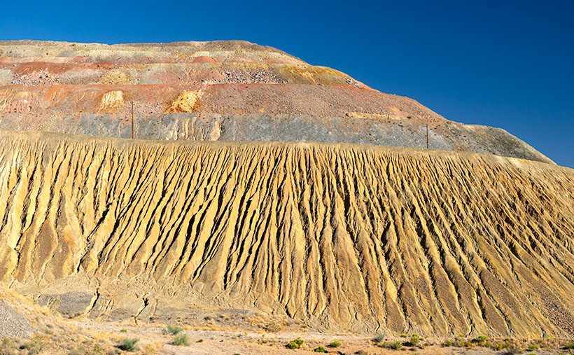
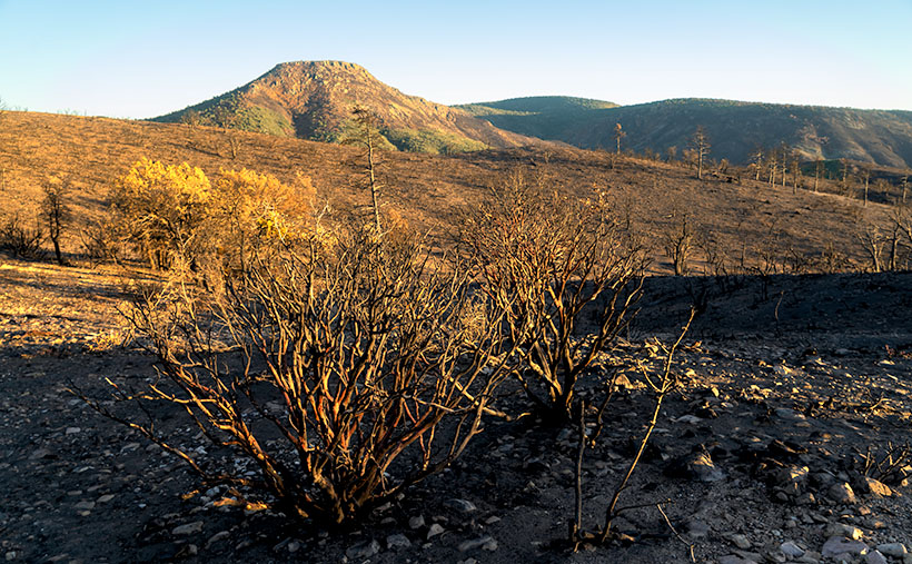
We turned around and started our journey home with the day getting late. We dallied along the way, making many stops for photos. Before the road began the ascent up the mountain, I spotted where the Big Sandy River had scoured 30-foot cliffs out of the mud banks. The formation was nearly circular, and you could imagine the raging water churning in a back eddy, a swirling whirlpool flowing against the river’s current. A large grove of Teddy Bear Cholla was growing inside the containment, so I grabbed my camera and hiked in for a shot.

Cholla Bay - The most dangerous cactus will attack you at the slightest provocation.
Cholla Bay – The most dangerous cactus will attack you at the slightest provocation.

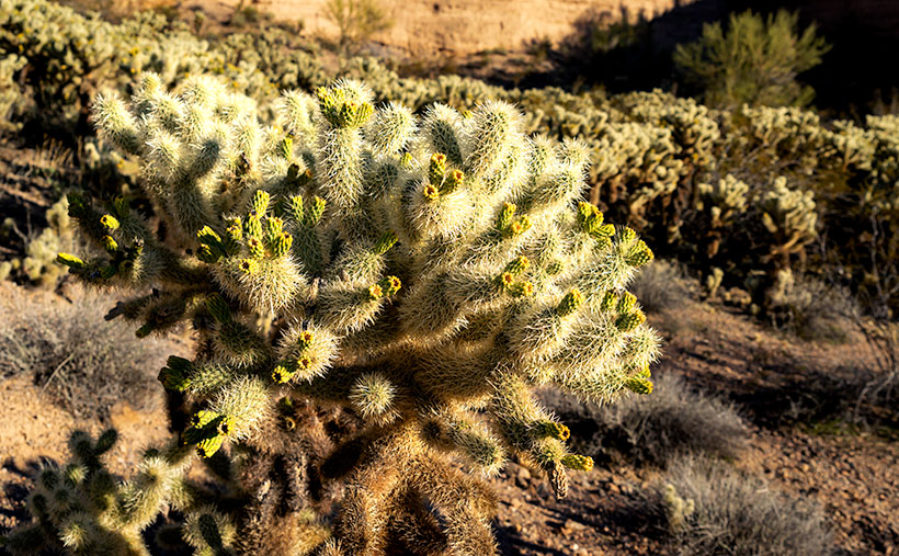
I have a love/hate relationship with the cholla cactus. When backlit, it has a soft fuzzy look that makes you want to jump into it like a pile of autumn leaves. It’s also known as Jumping Cholla, but it doesn’t do that. Its outer joints are fragile—hair trigger, if you will—and the tips break off from the main plant with the slightest disturbance. The needles are barbed, so if you get some into your skin, you have to pull them out with pliers—one by one.

Whenever I’m near Cholla, I move slowly and cautiously. I watch the ground for snakes, cow pies, and cholla balls. It’s like walking a tight wire. I don’t look up until I stop walking. So imagine how startled I was in the middle of this field when a wild gray burro popped his head up and snorted. He was just as frightened as I was and quickly galloped off to the far side of the road, but it took all my self-control not to stumble back through the cactus patch. Once the two jackasses safely separated, I regained my composure and took this picture, which I called Cholla Bay.

You can see a larger version of Cholla Bay on its Web Page by clicking here. I hope you enjoy viewing it. Join us next week when we finish our trip to the Poachie Mountains.

Until next time — jw

Big Wet Sandy Picture of the Week

“I know a shortcut.”

How many of you have heard those words and broken into a cold sweat? The road that Queen Anne and I decided to explore this month didn’t start as a shortcut. It was supposed to be a much longer trip, but it got cut short.

I had intended to drive to the north shore of Alamo Lake. There are a couple of exciting mountains I’ve seen from across the water when I last visited. The best road to get there starts in Wikieup. On my maps (including Google), there are two ways to get there. One is twenty miles south of Wikieup, and the other is about five miles south. Both roads go to the little town of Signal. I’m sure you spotted the signs on a drive to Las Vegas.

We decide to take 17 Mile Drive road. It’s the first left after the Nothing Gas Station. It’s a wide well-graded dirt road that climbs over a pass in the Poachie Mountains, then down into a valley where Signal is. The scenery at the pass is amazing—something we’ll get to later—and you can drive the route with your family station wagon. There’s one hitch along the way, and that’s crossing the Big Sandy River at Greenwood. Usually, crossing the river here could be tricky because—well, it’s deep sand, and you might get stuck without four-wheel drive.

Big Wet Sandy - The normally dry Big Sandy River flowing with water from recent rain.
Big Wet Sandy – The normally dry Big Sandy River was flowing with water from recent rain.

That wasn’t the case today. The Big Sandy was a real river and not in an ugly flash flood kind of way. Its waters flowed like it was an old river; clear and quiet. If I didn’t know better, I might have been tempted to pull out my waders and fly rod and make a few casts. It wouldn’t have been my worst day fishing, being the great angler that I am. There was no way to tell how deep the water was. It could have been two feet or a dozen, but it was not tempting enough for the police to cite me under the Stupid Motorist Law.

So, we’ll begin this month’s journey at the end and go backward. As I said, there was enough material to shoot in the mountains to fill a month, so we’ll save Alamo for another month, and we’ll start at the water’s edge.

I took this week’s featured image standing on the river’s bank. If I didn’t know, I would venture a guess that it was a photo of the Colorado River south of Bullhead City, and the mountains were in Nevada. Nope, it’s all Arizona. We’re looking north-east, and the peaks are actually on our side of the Big Sandy. The high point is Burro Peak. Although everything appears calm on this warm winter afternoon, the banks on each side of the water show erosion from raging water at some time. There are more cliff-banks like this—some higher—along the riverside past Wikieup that you can see from Highway 93. I wonder if I’ll ever again see a sight like this.

You can see a larger version of Big Wet Sandy on its Web Page by clicking here. I hope you enjoy viewing it. Join us next week as we start our return over the Poachie Mountains.

Until next time — jw

Ray Tailings Picture of the Week

Queen Anne's directives - From her royal coach, Anne delights in pointing the way we should've gone.
Queen Anne’s directives – From her royal coach, Anne delights in pointing the way we should’ve gone.

Picking a new back road to explore, photograph, and talk about is easy for some months. I may have seen a place that piqued my curiosity, and I’m ready to go. Other months are hard. I’ll pour over my maps, hoping to find inspiration. This month was different. When Queen Anne told me that she wanted to visit an ex in Florence (1), I knew right away which trail we’d be talking about in November. Of course, we’d pick the Florence-Kelvin Highway.

The highway between Florence and Kelvin is a 34-mile shortcut between the towns. Although it’s 13 miles shorter, driving around the Tortilla Mountains and through Superior using the paved highways is faster. I’ve partially traveled this road before when I photographed the Cochran site—the ghost town where only the coke ovens remain. They paved sixteen miles of the highway between Florence and the Cochran Road. It’s a long gentle grade rising 1500 feet. Then it winds through the Tortilla Mountains, past a couple of ranches, before descending into Kelvin—a small community along the north bank of the Gila River. Although there may be some wash boarding between gradings, the dirt is broad and doesn’t require a particular vehicle.

On this trip, Anne and I drove east to west, so we’d be somewhat closer to home. From Congress, we drove two and one-half hours to Superior, and most of that time was spent getting to the other side of Phoenix. In Superior, we turned south on County Road 177 to Kelvin—a community so small it doesn’t even have a Dollar Store. Something that Kelvin does have is the Ray open-pit copper mine currently managed by the Mexican mining company, Asarco. And it’s where I photographed this week’s featured image that I call Ray Tailings.

Ray Tailings - A 500-foot tall inside out mountain of mine tailings.
Ray Tailings – A 500-foot tall inside out mountain of mine tailings.

This operation is so massive that you see it on the east side of the highway for a couple of miles. The central pit—Jimmie Luck Gulch—looks like it could be used to mold giant Devo hats (“Whip it good“). In the middle of the Dripping Spring Range, the mineworkers have dug a negative mountain with terraces that the behemoth trucks use to haul ore to the surface. Digging that much dirt out of the ground to remove the copper, you have to stack the sterile waste somewhere, and that’s what I photographed for this week’s issue. It’s the mountain stacked up—inside out. The minerals found beneath the surface colors each layer. To me, the 500-foot pile looks like a gay-pride wedding cake.

It’s an impressive bit of technology to see, but it also causes environmental problems. Because the rocks and dirt are devoid of nutrients, unless scientists intervene, it will take centuries for plants to colonize the tailings. So that makes them susceptible to accelerated erosion. With each heavy rain, bit by bit, the pile makes its way into the Gila River and eventually the Sea of Cortez. That’s not good for the downstream people who rely on the river for clean water (Arizona Copper Co. vs. Gillespie).

You can see a larger version of Ray Tailings on its Web Page by clicking here. I hope you enjoy viewing it. Next week, we’ll continue along the Florence-Kelvin Highway, and I’ll show some of the natural beauty we found there.

Until next time — jw

(1). For those of you that live in another state, or don’t get the joke, Florence is the location of Arizona’s State Prison. She doesn’t really know anyone incarcerated there, but that’s not as funny.

Sheridan Manzanita Picture of the Week

Camp Wood Ponderosa - The late afternoon light adds a glow to a ponderosa pine grove at Camp Wood.
Camp Wood Ponderosa – The late afternoon light adds a glow to a ponderosa pine grove at Camp Wood.

East of Camp Wood, the road is wide and smooth as it rolls through the Santa Maria Mountain foothills. There are a few isolated places with washboards, but it’s quiet enough you might think that they paved it, although the plume of dust you see in the rearview mirror proves otherwise.

Queen Anne and I visited here the week after a heavy rain, so it packed down the dust, but the roadside troughs were full of debris. As we drove further, it looked like road crews had hosed the gutters with oil, because they were so black. We questioned if that was to keep the dust down, or were they preparing to pave the east end of Camp Wood Road. As soon as I got those questions out of my mouth, we rounded a bend and found a scene of utter destruction. On the north side of the trail, everything was normal, with pinions, chaparral, and gamble oak covering the landscape, but the south side was black and barren. Only charcoal-colored tree skeletons dotted the hills and valleys.

This road section was the location of the lightning-caused Sheridan Fire—one of those forest fires you watch on the evening news as they bomb the countryside with a fire retardant. The reporters tell you it’s near Prescott—but they’re always near Prescott—and it’s so remote that you don’t pay much attention. The fire started on August 5th, and it burnt through 22 thousand acres until early September rains finally put it out. I’ve never visited such a fresh burn site. Unbroken black ash covered the ground, and the rains washed some of it into the road gutters. The Forest Service blocked all of the side-roads, and hiking trails leading south with signs warning of fire danger.

Because Camp Wood Road is so wide here, it worked as an effectual fire break. The stark contrast between the left and right sides of the road drove home the destructive power of a forest fire. Although it looks like a barren wasteland now, within a few weeks, grasses will begin to sprout, and the fire area will renew itself. That’s how nature works.

Sheridan Manzanita - Red bark manzanita burnt in the 2019 Sheridan Fire near Camp Wood, Arizona
Sheridan Manzanita – Red bark manzanita burnt in the 2019 Sheridan Fire near Camp Wood, Arizona

When we got to a place where I could see Cottonwood Mountain as a backdrop, I stopped to take a few images. My favorite of the group is this week’s featured image. It shows burnt Manzanita skeletons in front of the flat-top mountain. Manzanita is one of my favorite plants because of its mahogany-colored bark, as you see in the photo. It only grows at higher altitudes in Arizona, and it’s hard to photograph because its dense round green leaves always hide the brightly colored branches. I called this image Sheridan Manzanita, and I hope you enjoy viewing it.

You can see a larger version of Sheridan Manzanita on its Web Page by clicking here. I hope you enjoy viewing it. Next week, we’ll make another stop along the Camp Wood road for yet another change of scenery. I hope you’ll join us.

Until next time — jw

Poughkeepsie Gulch Picture of the Week

Even though we had to wing it, I think that the day in the mountains Fred and I had was a very successful adventure. We both got a lot out of it. Fred was able to put his—new to him—Toyota FJ through its paces, we saw some beautiful rugged country, we took a lot of pictures, and we came back in one piece. When we got back to base camp, our wives—Deb and Queen Anne—knew we had a good time from the big bug-stained grins on our faces, and the incessant chattering about our day.

We visited four of the two dozen high passes in the San Juan Mountains, and those were the day’s high points (pun intended) of our trip. Coincidentally, that’s enough material for a typical month’s worth of blog posts. But September has five Sundays this year, so I get to show you another picture that I took; of the twenty-two keepers, this one is my favorite.

I don’t usually work this way. When I’m out alone with my camera, I try to work a scene. I’ll shoot several angles, zoom in and out, add or remove elements in the composition, or maybe wait for better light. When I’m back at my desk, I’ll review the raw files and pick out the best. I don’t bother processing most of my shots. In Colorado, we covered a lot of area in one afternoon, and I was just along for the ride, so I snapped pictures when I could before moving on. For most of the day, the light wasn’t to my liking, but the mountains were strong enough to stand up in less than ideal conditions. As dinner time approached, the sun’s color began to warm, and the scattered clouds cast shadows on the peaks.

Poughkeepsie Peak - The late afternoon sun shines on the top of Tuttle Mountain, which overlooks Poughkeepsie Gulch.
Poughkeepsie Peak – The late afternoon sun shines on the top of Tuttle Mountain, which overlooks Poughkeepsie Gulch.

We were almost done for the day, and as we approached Hurricane Pass, I saw this scene on the road overlooking Como Lake. I consider it the best of the day. It’s the fish you pull from the creel after the guys have finished laughing at the other minnows from your basket. It’s called Poughkeepsie Gulch. In this image, the warm afternoon sun is shining through a hole in the clouds on Tuttle Mountain’s top, which is otherwise covered in cloud shadows. The 13,203’ peak overlooks Poughkeepsie Gulch and down there, you can see the road the rangers warned us was too advanced for amateurs like us.

You can see a larger version of Poughkeepsie Gulch on its Web Page by clicking here. I hope you enjoy viewing it. Be sure to come back next week when we feature the scenery from another Arizona back road.

Until next time — jw

Engineer Pass Picture of the Week

When my friend Fred planned our off-road excursions through the San Juan Mountains, his initial itinerary was to complete the Alpine Loop, which includes two passes, circling Red Cloud Peak, Sunshine Peak (which are two of Colorado’s 14,000 foot mountains, but aren’t even in the top 10), and a stop in Lake City. Now that I’ve had time to recover and look at my maps, I think that would be a fabulous trip, especially if we did it later this month when the aspens turn color. But, when we stopped at the Silverton information center, he was told that it’s a seven-hour trip, and it was already afternoon, so we decided to sample some of the passes around Animas Forks instead.

Last week’s image was from Cinnamon Pass, and this week’s picture is from Engineer Pass—our second stop. Both of these places are along the Alpine Loop. If you do Cinnamon first, the route will be counter-clockwise and the opposite direction if you first go over Engineering Pass. The two passes are only miles apart, and most of the Alpine Loop is east of them. Although they’re relatively close, as the crow flies, driving the road requires descending 3,000 feet to the ghost town then 3,000 feet back up the other way. If I thought going up the mountain was exciting, going down was harrowing. I almost got out and walked.

Mountain Man Fred
Mountain Man Fred – It’s not an illusion that Fred’s hanging on to that wire. The sign is well over the slope, and the footing is unsure because of the loose shale.

As we rounded a corner, we saw a knoll where several vehicles were parked, and a crowd snapping selfies and taking in the view. We assumed this was it. It wasn’t. It was Odom Point, and we joined the others for the view and document our visit. As we returned to the road, a sign that said that our pass was further down the road, so we drove another couple hundred yards.

Engineer Pass
Engineer Pass – Looking north from the saddle, you can see two mule trails blazed by prospectors. One leads down into the valley while the other zig-zags up the unnamed peak.

This week’s image that I call Engineer Pass was taken from the 12,800-foot high mountain saddle looking north, and it shows an unnamed peak that’s another hundred feet higher. Also visible are two mule trails, one that descends into the valley and the other that cuts across the talus slope past the red streaks before a switchback as it zig-zags to the summit. I declined to try either of the trails.

While we were taking in the view, I turned around and was stunned to spot over a dozen cyclists peddling up the grade from Palmetto Gulch. No way! We were driving a jeep, and I was out of breath, while these guys were racing mountain bikes on the same road. It’s no wonder that Stephan Pastis ridicules bicyclists in his syndicated cartoon Pearls Before Swine. They’re insane.

You can see a larger version Engineer Pass on its Web Page by clicking here. Be sure to come back next week when we’ll continue exploring Colorado’s San Juan Mountains in Fred’s Toyota.

Until next time — jw

Pair of Threes

I’m all alone this week because Queen Anne has gone home to her sister’s because they made Christmas cookies this week, and Anne goes where the sugar is. For me, it’s good news and bad news. The good news is that the bleeding from my ears has stopped since the yelling ceased. The bad news is that I don’t have a copy editor this week, so this will be a short post. I don’t know how to spell all the big words she uses. She’s coming home on Thursday so things will be back to normal then. Pray for me.

Meanwhile back at the mines—or more specifically, San Domingo Wash where Anderson Mill is.

Back in the days when everybody used film—that’s the cellulose stuff you put in cameras to capture images before we used electrons—I was a stingy shooter. Because each frame cost a buck (sheet film was five-times that), I wouldn’t waste my money on something I wasn’t sure was good. Now that electrons are cheap (and the prices keep falling), I’ll snap just about anything that catches my eye. Often that shot turns out to be junk, but one out of a thousand deserves a second look. That’s how this week’s featured image happened.

Pair of Threes -Three saguaro along the ridge overlooking the San Domingo Wash where the Anderson Mill is. The three wispy clouds make up the pair.

If you’re the kind of person that lingers on every word that I write, you’ll recall that in my previous posts that the Anderson Mill structure is several stories tall and that the brothers welded it together as needed. In the short time that Fred and I were there, I wanted to poke around the different levels. Now, there are steel-treed stairs, but most of them didn’t have handrails. So I walked the truck paths that snaked up the hillside. It was at one of the switchbacks that I looked up and saw three saguaros along the ridge. Without thinking, I snapped the camera shutter and then dismissed it. When I saw that image on the computer, I knew I could use it because the clouds made the photo. I call this image Pair of Threes.

You can see a larger version of Pair of Threes on its Web Page by clicking here. I hope you enjoy viewing this week’s post and come back next week when we’ll show another featured image from San Domingo Wash.

Until next time — jw

BTW: Anne’s flight comes in after 11 pm. If you were a good friend, you’d pick her up … and keep her.